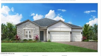
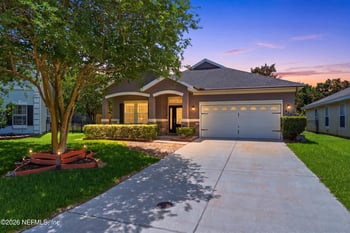
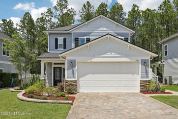
$759,000
Active
4
Beds
3
Baths
2800
Sqft
--
Acres
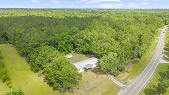
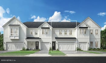
301 Pine Leaf Dr #166, St Augustine, FL 32092
MLS#: 2146682
St. Augustine FL homes for sale split fast by lifestyle: Historic District and Lincolnville for walkable old-city streets, Davis Shores for Matanzas River views and quick downtown access, Anastasia Island for beach days and A1A convenience, or Vilano for a quieter north-shore feel. Local reality check is routes first, romance second: if you cross the Bridge of Lions often, or you live on US-1, SR 312, or I-95 for workdays, let that drive decide the short list.


“St. Augustine” can mean very different day-to-day life depending on whether you’re closer to the Historic District, on Anastasia Island, up toward Vilano, or more inland near SR-16 and I-95. These quick notes are here to help you decide if the area fits your normal week, and what to verify early (by address, map, or document) so the home choice holds up after closing.
If your “easy week” includes a weekday dinner, a bayfront walk, or quick stops near St. George Street and the Plaza, St. Augustine can feel compact and usable—especially when you’re not fighting parking every time.
Certain weekends and seasons can change how the Historic District feels—traffic, parking, and “quick errands” becoming slower than expected. If that would frustrate you, plan a Saturday test drive before you shortlist.
The closer you get to the heart of downtown, the easier the “go out without planning” lifestyle can be. The trade-off is that parking rules and event patterns matter more—and you’ll feel it quickly if you live just outside the most convenient zones.
Most households end up leaning on a small set of routes: US-1 for daily runs, SR-16 for I-95 access, SR-312 to move between downtown and the island, and A1A when beach access is part of the week.
A “St. Augustine” mailing address may fall inside City of St. Augustine limits, St. Augustine Beach, or unincorporated St. Johns County—each can affect rules, services, and what you should verify. If schools matter, verify zoning by address.
City boundary map reference (official) | SJCSD attendance zone locator (official)
In and around the older parts of town, you’ll see more varied home ages and renovation styles. On the island and low-lying pockets, water context can matter. Treat flood map review as basic due diligence, not a conclusion.
If you want newer master-planned living and more “set routine” suburban convenience, homebuyers often compare St. Johns/Nocatee areas. If you want quieter coastal pockets with a different commute logic, some compare south toward Crescent Beach or north toward Ponte Vedra.
If you’re considering downtown-adjacent homes, do one weekday arrival (late afternoon) and one Saturday arrival using the parking you’d actually use. This tells you what “easy weeknight plans” will feel like.
If your short list is on Anastasia Island and your routines pull you across the Bridge of Lions often, confirm the opening schedule so you understand the “sometimes we wait” reality during certain trips.
“Near the beach” can still mean very different access depending on where you’ll park, which walkovers you’ll use, and whether you care about drive-on access. If beach time is part of your week, confirm the rules that match your plans.
St. Johns County beach access info (official) | Beach Services (official)
Before you treat a home as a finalist, run flood map context for the address. It’s not a label—just a fast way to guide insurance questions and “how does the yard handle heavy rain?” follow-ups.
Stand outside and listen—morning and late afternoon tend to be revealing. Homes near US-1, SR-312 approaches, or A1A can live differently than they look in photos.
If short-term rental use matters (now or later), confirm which jurisdiction the address is in and review the current rule-set. City rules and county rules are not the same, and HOAs can be stricter than both.
City of St. Augustine STR info (official) | St. Johns County STR ordinance info (official)
This is the practical test: would you come down here on a random weeknight without turning it into an “event”? If yes, that changes how St. Augustine feels day-to-day.
If you want a “clear the head” walk close to home, the bayfront and Castillo de San Marcos area is a repeatable, easy check. Try it once near sunset and you’ll know if it fits you.
For many households, this is the “we can get outside without planning” option—beach, trails, and a quick reset. If your home is close enough that you’ll actually use it midweek, it matters.
If live music and events are part of your life, this becomes one of the most-used “let’s do something tonight” anchors on the island side. Parking and arrival patterns are worth experiencing once.
Do not assume the rules and services just from the mailing address. Confirm whether the property is in City of St. Augustine limits, St. Augustine Beach, or unincorporated St. Johns County before you rely on any “rule talk.”
City boundary map reference (official) | St. Johns County iMap (official)
If schools affect your decision, verify the zoned schools for the exact address and re-check for the current school year before you commit. Boundaries and options can change.
Treat this as standard due diligence—especially if you’re near the Matanzas River, salt marsh edges, or lower-lying streets. Use it to guide questions, not to draw conclusions.
If connectivity affects your work or routines, confirm what’s available at the specific address before you treat the home as a finalist. Results can vary street to street.
If you’re down to a short list, do one weekday drive (late afternoon) and one Saturday pass using your real errand routes—US-1, SR-16, and SR-312 if you’ll cross between downtown and the island. Then run the jurisdiction + flood + school checks above before you treat any address as “the one.”
When you search St. Augustine, FL homes for sale, the city name on a listing can describe more than one jurisdiction. “St. Augustine” might mean the City of St. Augustine, the separate City of St. Augustine Beach, or an unincorporated St. Johns County address. That distinction matters because it can change the rule-set you live under and the documentation you should verify for that specific parcel.
The other practical divider is whether your weekly routine depends on crossing to Anastasia Island. If your regular drives lean on A1A and the Bridge of Lions, drawbridge openings can affect timing during the day. That’s not a deal-breaker or a promise—just something worth confirming early if you’ll be crossing at specific hours.
If two listings both say “St. Augustine,” these are the quick checks that usually clarify what you’re actually comparing—and what you should verify before you commit.
In the City of St. Augustine, zoning context is one of the fastest ways to reduce “surprise” later—especially when a listing description sounds flexible, but the rule-set is tighter than it reads. The workbooks are useful because they let you keep your due diligence tied to the address and the documented framework, not the marketing language.
If short-term rental rules are part of your decision (even as a future option), keep it address-specific and time-variable. Use the City’s official page as the source of truth for properties inside City limits.
Short-term rentals (City of St. Augustine)
World Golf Village sits in a different weekly pattern than the historic core or the beach side. For most homebuyers, it reads as more drive-first and more dependent on how often you’ll use SR-16 and I-95 for work, errands, and regional services.
One practical note for due diligence: the World Golf Hall of Fame site in St. Augustine is closed, and the broader area is in active transition and redevelopment planning. If World Golf Village is on your shortlist, treat “what’s coming next” as time-variable and keep one official county update bookmarked so you’re not relying on outdated language.
World Golf Hall of Fame closure note | St. Johns County: update on World Golf Village
If you’re drawn to downtown-adjacent St. Augustine real estate, the decision is usually simple: are you comfortable living in a place where you manage the car first, then do most of the day on foot? Historic downtown has narrow streets and a lot of one-ways by design, and parking availability changes block by block. That can feel like a good trade-off for your day-to-day life, or it can feel like friction you don’t want to carry into a normal week.
Homebuyers who end up happiest near the historic district tend to think in practical defaults: where do we park, and what’s the walk in. A common reference point is the City’s Historic Downtown Parking Facility next to the Visitor Information Center, because it’s built for “park once, then walk” days and puts you within an easy walk of St. George Street and surrounding blocks.
The upside is obvious: you can treat dinner, coffee, and a walk through the historic district as something you do on a normal week. The trade-off is that parking rules and enforcement windows can vary by location and are posted, and “quick stops” can take a little more timing than they would in a drive-first area. If that’s a deciding factor for you, treat the City’s parking pages as the current source of truth.
City parking overview | Street & lot parking downtown | Historic Downtown Parking Facility
A midday showing can make any location feel easy. The better test is your normal week: getting home after dark, a friend stopping by, a delivery, and the “we’ll be out for an hour” kind of errands. These are the moments that usually decide whether downtown-adjacent living feels worth it for you.
Even if you never attend, Nights of Lights is a straightforward reminder that historic downtown has real peak-pressure dates. The City runs a free park-and-ride shuttle on select high-attendance days during the season, and the schedule is time-variable—treat it as “check this year” rather than assuming it’s the same every season.
The City’s official shuttle page lists the perimeter lots used for the free shuttle, including: Broudy’s Lot (198 W. King Street), North San Marco Lot (301 San Marco Avenue), and the St. Johns County Health Department lot (200 San Sebastian View).
Nights of Lights free shuttle (City of St. Augustine) | Nights of Lights details (City of St. Augustine)
If downtown-adjacent living is on your shortlist, a practical next step is to do one early-evening pass on a normal weekday and one pass during a busier window. If both feel workable for your routine, you’ll have much higher confidence that the location will still feel right after closing.
When homebuyers compare island-side St. Augustine homes for sale, the practical question is simple: how often will you cross into the historic downtown/mainland side, and will you mind waiting when the bridge is open for marine traffic? For some households it’s an occasional inconvenience. For others, it becomes a regular “leave a little earlier” habit depending on work hours, school runs, and evening plans.
You’ll feel this most in Davis Shores, where Anastasia Boulevard (A1A) funnels toward the Bridge of Lions, and in parts of St. Augustine Beach where downtown trips are still part of the week. The island-side map looks close; the day-to-day difference is whether your routine depends on that crossing at specific times.
The City of St. Augustine posts the Bridge of Lions opening schedule. Because schedules and exceptions can change, treat this as time-variable and confirm current guidance during the same windows you would normally drive.
The upside of island-side St. Augustine real estate is straightforward: beach access is close, and downtown is still usable for many households. The trade-off is that you may start planning around crossings on days when you need to be on the mainland side, while some errands naturally shift to A1A-side stops depending on where you spend most of your week.
These are the moments that tend to clarify whether island-side routing feels easy for you or feels like something you’ll manage all week.
If Davis Shores or St. Augustine Beach is on your shortlist, do one loop that matches your real week: cross into the historic district and back during an early-evening window, then do it again on a weekend window. You’re not trying to “prove” anything—you’re checking whether the timing feels acceptable for your routine.
City of St. Augustine: Neighborhood Zoning Workbooks | City of St. Augustine Beach
If you’re comparing St. Augustine homes for sale near downtown, Nights of Lights is a useful seasonal test. On select high-attendance nights, the City shifts many visitors into perimeter lots and runs a free shuttle so downtown streets and parking don’t carry all the demand at once. That matters for St. Augustine real estate decisions because it affects the roads you use, the blocks you park on, and how predictable evenings feel during the season.
For the 2025–2026 season, the City lists Nights of Lights running from November 15, 2025 through January 11, 2026. Dates and shuttle operations can change year to year, so treat this as time-variable and confirm the current plan if you’re making a near-downtown move decision right now.
The City’s shuttle information is the best “current source” because the service runs on select peak dates and can expand or contract depending on the season.
Nights of Lights Free Shuttle (City of St. Augustine) | Nights of Lights season overview (City) | Light-Up! Night + season dates (City)
These lots are the practical map points to know because they indicate where the City routes many visitors before they enter the historic district. If your normal route home runs along these same approaches, you’ll notice peak nights more than someone coming in from another direction.
Reference: the City’s shuttle page and St. Johns County’s service notes list these lots for peak-date operations. County summary (St. Johns County)
This isn’t about liking or disliking the event. It’s about whether you want to live where a handful of nights each season can change how you get home, where guests park, and how easy it is to “pop downtown” without thinking about timing. If your short list includes addresses near King Street, San Marco Avenue, or San Sebastian View, treat the shuttle plan as a relevant part of the weekly pattern during the season.
Verification hook (time-variable): confirm the current-year shuttle dates and operating hours here: City of St. Augustine Free Shuttle page.
“Near the beach” can mean two very different weeks. One address supports a true walk-and-go routine. Another turns into drive, park, carry your stuff, and time it. The difference is usually the access point you’ll actually use—where you enter, where you park, and whether the walkover and crossings feel workable when it’s hot, windy, or you’re trying to squeeze in an hour before dinner.
These checks keep the decision grounded in what you’ll actually do—parking, crossings, and the access point you’ll use most—without relying on listing language.
A lot of St. Augustine real estate decisions come down to what you do when it’s not a special occasion. This is the short list of outdoor places that show up in normal life—beach access you’ll actually use, trails that are easy enough to repeat, and parks that work when you just want to get outside for an hour.
If fishing is part of your week: St. Johns County Pier info
When you’re deciding on St. Augustine homes for sale, the “fit” usually shows up in the drives you repeat: the bigger errand run out toward SR-16 and I-95 (Exit 318), the occasional trip to 500 San Sebastian View for county services, and the hospital route to UF Health Flagler Hospital. A map can make everything look close. The more honest question is whether these drives feel easy from your short list—or whether you’ll catch yourself re-planning them every week.
This is where a lot of “get it done” shopping naturally pulls, especially if you want to stay out of downtown streets. If your home is downtown-adjacent or island-side, it’s worth feeling how US-1, SR-312, or the Bridge of Lions choice affects that run on a normal weekday.
This address is a practical reference point for county business. The drive is a good way to learn how your pocket handles US-1 timing and turns—especially if you’ll be crossing from the island side or coming in from north/south of town.
Most homebuyers don’t want the closest hospital on paper—they want a route that feels straightforward when it matters. From different parts of town, you’ll typically find yourself choosing between SR-312 routes or bridge crossings, depending on where you live and where you’re headed next.
FloridaHealthFinder profile (official listing) | UF Health St. Johns
If St. Augustine real estate is on your shortlist, do one drive that matches your real week: start at the house, then head toward SR-16 / I-95 Exit 318, continue toward UF Health Flagler Hospital, and finish by passing 500 San Sebastian View. You’re not trying to “solve traffic.” You’re learning whether the routes you’ll repeat feel natural from that address.
When you’re shopping St. Augustine homes for sale, dining becomes less about “what’s popular” and more about what you’ll actually do on a normal week. The practical question is: where do you realistically go on a random Tuesday—and does the parking, bridge timing, and drive feel fine when you’re tired and just want dinner handled?
St. Augustine real estate can live three different ways at night: park-and-walk downtown, near-downtown with quicker in-and-out (U.S. 1 / San Marco direction), or stay island-side around A1A and cross over when you plan to. None is “right.” The fit is whether you’ll actually repeat the routine.
If markets and shows are part of your normal weekends, the venue calendar is useful for planning your “busy-window” test: St. Augustine Amphitheatre venue info.
One of the easiest ways to regret a St. Augustine home isn’t the inspection—it’s assuming the address can do what you want it to do later. Two homes can look similar from the street and still sit under different rules depending on whether the property is in the City of St. Augustine, the City of St. Augustine Beach, or unincorporated St. Johns County. Treat two checks as standard: what the property is allowed to do and what work was actually approved.
Inside City limits, the Neighborhood Zoning Workbooks are a fast way to match a listing’s neighborhood label to the rules that actually apply. If something is described as “Old City” or “historic,” this is where you separate the vibe from the written rule set.
Near the historic core (around Castillo de San Marcos and downtown), exterior changes can come with extra review layers. Treat that as a prompt to verify zoning and overlays before you assume a fence, driveway change, addition, or rental use will be simple.
If a home looks renovated, make sure the visible work matches the paper trail. Your lookup source depends on City vs. Beach vs. County—so confirm jurisdiction first, then verify permits before you treat the updates as “done right.”
One of the most common “wait, what?” moments after closing in St. Augustine isn’t the house—it’s the basics: who bills you for water, whether you’re on sewer or septic, and which day the bins go out. The reason is simple: the “St. Augustine” label covers multiple jurisdictions. Treat utilities like an address-level fact, not something you guess from a ZIP code or a listing description.
The most common version is a home that looks “in town” online, then you learn after closing that the billing or pickup schedule follows a different boundary—especially when you’re close to the City/County lines or comparing mainland vs. island-side options.
Some addresses are served through City of St. Augustine Utilities, and others through St. Johns County Utility. That changes billing setup, service rules, and who you call when something needs attention. Verify the provider by address before you assume two “St. Augustine” listings live the same way.
This is a quiet difference that changes your maintenance expectations and what “normal” upkeep looks like. Don’t assume properties match just because they’re both marketed as St. Augustine—confirm the wastewater setup for the parcel using the correct City/County sources for that address.
Pickup days can change by municipality (City vs. Beach vs. unincorporated County). In City limits, the schedule breaks service into areas like north/south of King Street or Anastasia Island. Verify the official schedule for the exact address so you’re not surprised by “wrong day” bin chaos after move-in.
In parts of the St. Augustine real estate market—especially newer, amenity-driven neighborhoods—the rules can affect daily life as much as the floor plan does. The catch is that a big neighborhood name on a sign (or in a listing) doesn’t always tell you which HOA documents or which CDD applies to your exact street. The good news: you can verify it cleanly, because the districts publish current-year materials and the recorded plats and restrictions are public record.
In Palencia, Marshall Creek CDD and Sweetwater Creek CDD are not interchangeable. Two homes can both say “Palencia” and still fall under different district paperwork depending on location and phase. Before you treat a home as a finalist, match the address to the correct CDD and HOA documents.
This is where the practical stuff lives: easements, lot lines, common areas, drainage features, and restrictions that can affect fences, parking, storage, and exterior changes. If you want fewer surprises after closing, pull the recorded plat and restrictions for the exact subdivision and phase tied to the address.
When homebuyers get frustrated later, it’s rarely a fine-print rule nobody uses—it’s something that hits weekly: parking and guest limits, trailer/boat storage, exterior approvals, short-term rental limits, and amenity access rules. For CDDs, budgets and assessments can change by fiscal year, so always pull the current-year documents on the district site.
Use this when a neighborhood name feels bigger than the specific street you’re touring. It keeps your due diligence tied to the lot you’re actually buying.
If schools are part of why you’re shopping St. Augustine homes for sale, the safest habit is simple: verify the assignment by exact address. In St. Johns County, two homes that feel “basically the same spot” can feed different schools because boundaries follow specific map lines and road breaks—not neighborhood names, ZIP codes, or whatever a listing headline says.
In and around St. Augustine, zoning lines often track practical dividers—major roads, older neighborhood edges, and newer development phases. That’s why the locator beats guesswork. If the home is on (or near) a boundary, don’t debate it—run the address and save the result.
Zones can change as new schools open and boundaries get updated. The district posts current tools and any upcoming zoning items on the Attendance Zoning page, so treat it as your source of truth—especially if you’re buying months ahead of a school year start.
Even when you like the assigned schools, you still want to confirm the practical stuff: bus eligibility, start times, and any choice/program options that matter to your household. Those details live on separate district pages—so don’t let “I heard…” become the deciding factor.
When homebuyers look at St. Augustine FL homes for sale, the “St. Augustine” part can hide the real decision. This is a town where two addresses can be close on a map and still feel different in a normal week. Downtown nights on St. George Street and the bayfront are one kind of life. A week built around State Road 16 (SR-16) errands and quick I-95 access is another. And if you’re island-side or beach-side, the Bridge of Lions and A1A tend to show up in your routines more than you expect.
If you take one thing from this: choose based on routine. Think about where you’ll be on a normal Tuesday, and how often you’ll be driving into the historic area or crossing to the island side.
If you’re torn, the deciding detail is usually simple: do you want most of your week to happen west-of-town near SR-16 and I-95, or do you want to be close enough to downtown that you’ll actually use it on a weeknight?
Once a home feels like a real candidate, these are the details that usually separate “good idea” from “good fit” in St. Augustine—because they can vary street by street.
The simplest mindset here is: choose the home you like, then make sure the address matches the week you want. In St. Augustine, that’s where the real differences show up.
These are the questions that come up once you stop browsing photos and start picturing your normal week. Each answer points to a simple way to confirm the important details by address, so your St. Augustine real estate decisions don’t depend on guesswork.