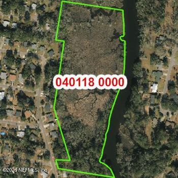


Jacksonville is considering $1,818,000 to acquire three parcels along the Ribault River. At one of them, 0 New Kings Road, Home904's check of the city's flood maps found two different mapped hazard areas touching the same parcel.
That matters when researching a home near the river. A flood-zone boundary can cross a property without covering the entire lot or building.
As of November 13, 2026, Ordinance 2026-0866 remains in committee. The proposal would fund land purchases for Jacksonville's Resilient Ribault Initiative.
1. Would the Ribault River purchase reduce flood risk?
The ordinance proposes funding the acquisition of three District 10 parcels. One is at 0 New Kings Road, parcel 040554-0010. Two are at 0 Pope Place, parcels 040542-0000 and 040542-0025.
Introduced October 27, the legislation received a public hearing and second reading on November 10 before being referred again. It's scheduled for the Neighborhoods, Community Services, Public Health and Safety Committee on November 16 at 1 p.m., followed by the Finance Committee on November 17 at 1 p.m..
A vote to approve the ordinance would authorize funding and agreements. The city would still need to complete the acquisitions.
The city's capital plan project sheet says the parcels are intended to become resilience parks that can hold floodwater. The goal is to avoid additional flooding associated with development and impervious surfaces. The sheet allocates $1,818,000 for land acquisition and site preparation and lists 2028 as the proposed project completion year. It provides no separate construction or design budget, construction start date or estimate of reduced flood risk for neighboring homes. The 2028 date is a proposed target, not a guarantee of completed parks.
St. Johns Riverkeeper has also advocated for riverfront land acquisition to preserve a buffer and improve opportunities for public access. That potential access is the organization's stated aim, not a confirmed feature of an approved park design.
2. What does Jacksonville's flood zone map show at your address?
Home904 compared Jacksonville's public parcel boundaries with the city's flood-zone mapping layer.
Both Pope Place parcels intersect mapped Zone AE. The New Kings Road parcel intersects Zone AE and a separate area labeled 0.2% annual chance flood hazard.
Zone AE identifies an area associated with the 1%-annual-chance flood, commonly called the 100-year flood, with established base flood elevations. The 0.2%-annual-chance classification identifies a different modeled flood hazard area, often associated with the 500-year flood.
The labels describe modeled hazards, not guarantees about which areas will stay dry. And the New Kings Road result doesn't mean both classifications cover the entire parcel.
Open Jacksonville's Duval Civil Planning map, search for an address and enable Layers → Flood Plains → Flood Zones. The city's flood-zone guidance explains the process.
Look at where the mapped boundary crosses the lot, then locate the house itself. A flood zone may extend through part of a yard without reaching the building. In another case, the boundary might cross part of the structure.
If the line is close, use FEMA's Flood Map Service Center to check the effective map and ask the appropriate floodplain official and lender to confirm how the building is classified.
Home904's Northeast Florida flood-zone guide walks through the address-level research.
3. What do the Florida flood disclosure form and insurance quote show?
A flood map shows modeled hazards. It doesn't tell you whether water previously entered a house, collected in the driveway or blocked the street.
Florida's flood disclosure law, Section 689.302, requires residential sellers to provide the state's flood disclosure at or before the sales contract is executed.
The form asks whether the seller knows of flooding that damaged the property while they owned it, filed a flood-damage insurance claim or received flood assistance.
Ask for it early. If the seller reports damage, request the relevant dates and repair records so you can understand what happened and what work followed.
Street access deserves a separate question. A homeowner may have avoided damage inside the building while dealing with standing water in the yard or roadway during heavy rain or high river levels. Ask about those conditions and have a property inspector evaluate visible lot drainage and building concerns.
Before setting a buying budget, request an address-specific flood-insurance quote showing the premium, coverage and deductible. Have the lender confirm whether the proposed mortgage requires flood coverage. Existing homeowners can review the same questions with their insurance agent.
Home904's Northeast Florida flood-insurance guide explains why a property's location and building characteristics matter when evaluating coverage.
If you're comparing Jacksonville homes, see how Home904 helps buyers prepare the address-specific questions worth resolving before making an offer.